Road Condition Indexing using crowd sourced connected vehicle data

A nations road network is critical for promoting economic and social development by allowing the efficient movement of goods and people over large distances. Providing a safe and efficient road network is therefore of paramount importance, and key to this are effective road maintenance strategies.
NIRA’s previous article (Pettinari, 2024) explored the use of NIRA’s roughness data in corrective and preventive road maintenance. In this article we will explore the use of NIRA Dynamics data in the development of pavement condition indices.
- Pavement condition indices
Pavement condition indices are often derived from detailed pavement condition data and are generally provided as:
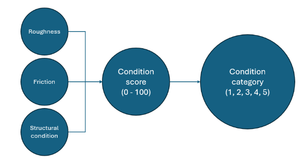
- condition scores, typically reported on a scale from 0 to 100. Often used for site identification and maintenance prioritization.
- condition categories, typically derived from the condition scores and reported on a 1-5 or red, amber, green scale. Often used for network level monitoring, national reporting, high level site identification, and maintenance prioritization.
This is illustrated in Figure 1 which shows the progression of road surface condition data (roughness, friction, etc…) to condition scoring and condition categorization.

Several pavement condition indices are available, for example:
- the Road Condition Index (RCI) is typically used in the UK,
- the Pavement Condition Index (PCI) is used in the USA,
- the International Roughness Index (IRI) is used in large parts of the global south, and the US.
The collection of data used in deriving road condition indices is typically prescriptive, standardized, and uses either bespoke equipment or manual engineer surveys. In the case of the PCI and RCI a strict ruleset is applied to road condition data to derive an PCI or RCI score.
In recent years, technological advancements, largely driven by the automotive industry, have revolutionized road condition monitoring by harnessing crowd sourced connected vehicle data and NIRA Dynamics are at the forefront of this revolution.
2. Using connected vehicle data to derive pavement condition indicesModern vehicles are outfitted with a vast sensor array, monitoring many aspects of the vehicle such as location (GPS), wheel speeds, acceleration, control inputs etc... NIRA Dynamics work closely with the automotive industry to collect, process, analyze, and generate insight from these data for use in roads management.
NIRA have developed two road condition indices, the NPCC and NPCI which are detailed in the following sections. For the generation of these indices three main data sources are used:
- Roughness; NIRA’s roughness data are representative of the IRI. These data are collected continuously by all connected vehicles allowing insight to be generated through the analysis of daily and long term roughness values (see (Pettinari, 2024)).
- Friction; NIRA’s friction data are provided by NIRA’s Tire Grip Indicator (TGI), a bespoke piece of software installed on the vehicle by the OEM. This software processes vehicle sensor data in real time to determine the maximum available friction between the road surface and the vehicle tire during even light maneuvering.
- Potholes; NIRA’s road irregularities data provide the location, magnitude, and development rate of potholes by assessing vehicle wheel speed and accelerometer data.
NIRA’s pavement condition indices are generated through advanced statistical models using features which describe the current condition of the road, and with the progression of road condition with time. Snapshot roughness and friction data are used to assess the current surface condition of the pavement, and roughness trends are used to assess the structural condition of the road. Potholes data provide additional information which could be indicative of wider structural issues in the pavement.
3. The NIRA Pavement Condition Category (NPCC)The English Department for Transport (DfT), in conjunction with the Transport Research Laboratory (TRL), have developed a draft standard (PAS 2161) (British Standards Institute, 2024) which modernizes the collection and reporting of road condition data for national reporting for the English local road network. This standard presents a new road condition categorization technique which moves away from prescriptive rule-based standards and towards a performance based approach aimed at getting the ‘right’ answer, but with strict performance criteria. This move will allow road authorities to use the most appropriate data for them in a cost-effective way.
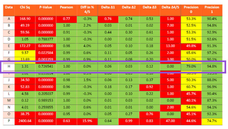
As part of the PAS 2161 development, TRL carried out an exploratory study into the collection of road condition data to identify and address the technical challenges involved. The study report (Wright & Brittain, 2024) can be downloaded from (https://trl.co.uk/publications/road-condition-monitoring-data---network-study). NIRA Dynamics proudly took part in this study and in the linked report, NIRA Dynamics were participant “H”.
To support this study NIRA Dynamics developed the NPCC by applying advanced data analytics, and expert knowledge in the field, to a wealth of pavement condition data. NPCC data were provided to TRL for a pre-described route against which they would be compared with Pavement Condition Categories (PCCs) generated through a consensus of highways engineers. TRL assessed the level of agreement between the NPCC and PCC results using several metrics.
The results of the study have been presented from the study report in Figure 2. Multiple technologies were assessed as part of this study and NIRA’s results have been highlighted in the purple box. Of note are the ‘Precision 0’ and ‘Precision 1’ columns, which show the percentage of 100m sections where the NPCIs and PCIs were identical (Precision 0), and where NPCIs were within one category of the PCIs (Precision 1).

The study results were highly promising and provided very positive indications about the robustness and validity of PAS 2161. The study results also demonstrate the ability of connected vehicle data, and advanced data analytics in providing robust road condition metrics.
4. The NIRA Pavement Condition Index (NPCI)Following the success of the NPCC, the NPCI was developed using the same advanced techniques in data collection and analytics. The model features used in generation of NPCCs were further developed, and the model was tuned so that the outputs would be reflect the Pavement Condition Index scores (PCI scores) used in the United States. The NPCI scores were then categorized into NCPI categories using the demarcations applied to PCI scores.
To assess the performance of the NPCI, publicly available PCI data were gathered for a major US city. A portion of these data were used in the development of the NPCI, and a separate portion of the data was held for the verification of the NPCI.
The results of the NPCI verification are presented below. Two accuracy scores were developed to characterize how closely the NPCI categories matched the PCI categories. Accuracy 0 is the percentage of NPCI categories that were identical to the reference PCI categories, and Accuracy 1 is the percentage of NPCI categories that were within 1 category of the reference PCI categories. The values obtained were 62.2%, and 93.5% respectively, which are broadly similar to those obtained for the NPCC (Wright & Brittain, 2024).
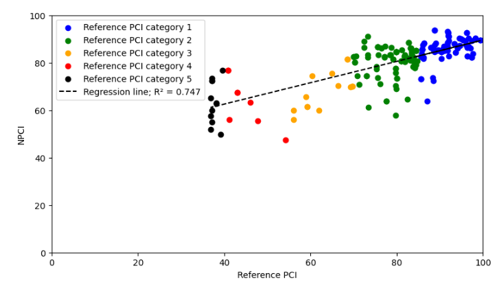
The second piece of verification was to identify the level of correlation between the NPCI scores with the PCI scores (Figure 3). The R2 for this correlation was 0.75 which shows that connected vehicle data can explain about 75% of the variance in the PCI scores.

The remaining variance in the reference PCI scores could be explained through the following:
- The NPCI uses both snapshot data (the most recent roughness measurements) and long-term roughness trends to determine pavement condition. Longer term roughness trends tend to be representative of the structural condition of the pavement, whereas snapshot data tends to be related to the surface condition of the pavement. It is therefore possible that the NPCI has identified locations with poor structural condition which is generally not considered in the reference PCI scores.
- The reference PCI scores represent the pavement condition of an entire junction to junction pavement segment. For major roads, these segments can be very long and contain a range of pavement conditions along their length. Taking a more detailed look at the PCI data would allow for a more accurate determination of the pavement condition.
The NPCC and the NPCI demonstrate the power of connected vehicle road condition data in deriving pavement condition indices. The reference data collected for the development of the NPCC and the NPCI were markedly different. For the NPCC, engineers were employed to categorize the condition of road pavements directly, that is, they made quick and direct decisions about the condition of the pavement. In contrast for the NPCI highly prescriptive methodology and strict ruleset was used.
NIRA Dynamics road condition data were used to accurately replicate pavement condition indices generated under both of these paradigms. This means that indices could be developed to reflect the condition of pavements in line with any other road condition index.
The combination of NIRA’s detailed road condition insights (Pettinari, 2024), and NIRA’s road condition indices, allows road owners to extract the maximum value from cost effective, high resolution, and continuously collected, connected vehicle road condition data.
6. ReferencesBritish Standards Institute. (2024). PAS 2161:2024 Road condition monitoring (RCM) data – Specification. London: British Standards Institute.
Pettiniri , M. (2024). Corrective and Preventive Maintenance using NIRA Roughness Data. Linköping: NIRA Dynamics AB.
Wright, A., & Brittain, S. (2024). PPR2042 Road condition monitoring data: Network Study. Wokingham: TRL.
Read previous articles:
https://www.niradynamics.com/latest/corrective-preventive-maintenance-using-nira-roughness-data
https://www.niradynamics.com/latest/friction-the-critical-factor-in-optimizing-road-maintenance
https://www.niradynamics.com/latest/unlocking-high-frequency-time-domain-in-roughness-measurements


